Mather Point is where many South Rim visitors see the Grand Canyon for the first time. A short paved walk from the Grand Canyon Visitor Center leads to broad views across the central canyon, making it one of the easiest major overlooks to include in a first-time itinerary.
Its convenience is also its principal drawback. Mather Point can become extremely busy near sunrise, sunset and during the middle of the day. Visitors who continue a short distance along the Rim Trail can often find quieter viewing areas without giving up the same sweeping scenery.
Mather Point is best used as the beginning of a South Rim visit rather than the only viewpoint. From here, visitors can walk to Yavapai Point, explore the geology museum, board park transportation or continue into Grand Canyon Village.
Best First-Time Plan
Park at the Grand Canyon Visitor Center, walk to Mather Point and then continue approximately 0.7 mile west along the paved Rim Trail to Yavapai Point and the Yavapai Geology Museum.
This short route provides two different canyon perspectives, an easy rim walk and a useful introduction to Grand Canyon geology.
| Mather Point at a Glance | What to Know |
|---|---|
| Location | South Rim near the Grand Canyon Visitor Center |
| Best for | A first Grand Canyon view, sunrise and accessible sightseeing |
| Walking distance | Approximately five minutes from the Visitor Center plaza |
| Trail surface | Paved paths and developed viewing areas |
| Parking | Visitor Center parking lots 1 through 4 |
| Restrooms | Available in the Visitor Center plaza area |
| Food and drinks | Cafe and grab-and-go options near the Visitor Center |
| Typical visit | 30 to 60 minutes; longer when walking to Yavapai Point |
| Entrance fee | Included with Grand Canyon National Park admission |
| Pets | Leashed pets are permitted on the paved Rim Trail |
What to See and Do at Mather Point
The View from Mather Point
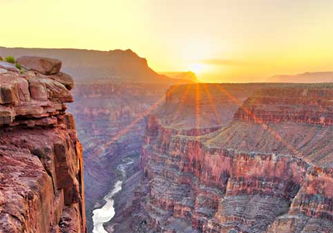
Mather Point overlooks the central portion of Grand Canyon. On a clear day, visibility may extend more than 30 miles to the east and 60 miles to the west.
From the developed viewing areas, visitors can see layers of cliffs, buttes, temples and side canyons stretching toward the North Rim. Small portions of the Colorado River may be visible far below, along with the Phantom Ranch area and trails crossing the inner canyon.
The canyon’s scale is difficult to understand from a single photograph. Walking between the main viewing platforms and nearby Rim Trail overlooks reveals how dramatically the foreground and visible rock formations change over short distances.
Main Viewing Areas
Mather Point includes more than one place to stand and look into the canyon. Paved paths connect the principal viewing platforms with several smaller rim overlooks.
The primary platforms have protective railings and provide unobstructed views into the canyon. Nearby paths offer additional viewing angles and distribute visitors across a wider section of the rim.
Rather than crowding around the first opening in the trees, continue toward the main platforms and then walk a few minutes in either direction. The scenery remains strong while the atmosphere often becomes noticeably calmer.
Mather Point Amphitheater
A stone amphitheater sits just east of the primary Mather Point viewing area. It provides tiered seating overlooking the canyon and may be used for ranger programs or special events.
Even when no program is scheduled, the amphitheater is a useful place to sit, rest and study the landscape. Views include the Colorado River corridor, Zoroaster Temple and the opening of Bright Angel Canyon across the canyon.
Walk from Mather Point to Yavapai Point
The paved Rim Trail continues west from Mather Point to Yavapai Point and the Yavapai Geology Museum. The distance is approximately 0.7 mile one way.
This is one of the best short walks at the South Rim because the route remains close to the canyon edge and offers frequent viewpoints. The walk is mostly paved and avoids the steep elevation changes found on trails below the rim.
At Yavapai Point, the geology museum uses maps, exhibits and labeled panoramic windows to explain the formations visible across the canyon.
Visitors can walk back to Mather Point or use current park transportation when available.
Continue to the Yavapai Point guide »
Walk East on the Rim Trail
The Rim Trail also continues east from Mather Point toward Pipe Creek Vista and the South Kaibab Trailhead area.
This direction generally becomes quieter as visitors move away from the Visitor Center. It is useful for travelers who want a longer rim walk, additional viewpoints or a connection with the eastern portion of the South Rim transportation system.
The complete Rim Trail extends approximately 13 miles between the South Kaibab Trailhead area and Hermits Rest. Most visitors complete only a short section.
Plan a walk on the Grand Canyon Rim Trail »
Is Mather Point Worth Visiting?
Yes, particularly for first-time visitors entering through the South Entrance. Mather Point combines a major canyon view with nearby parking, restrooms, visitor information and connections to the Rim Trail.
It is less essential for repeat visitors who already plan to explore Hermit Road, Desert View Drive or quieter sections of the rim. Its greatest value is convenience rather than solitude.
Visitors arriving through the East Entrance may prefer to make Desert View their first major overlook and visit Mather Point later in the day.
Sunrise, Sunset and Photography
Mather Point at Sunrise
Mather Point is one of the most practical sunrise locations on the South Rim. Its broad eastern view, large nearby parking area and short paved approach make it easier to reach before daylight than overlooks requiring longer drives or specialized transportation.
Arrive at least 30 minutes before the published sunrise time. The canyon often begins changing color before the sun clears the horizon, and parking areas can fill quickly during busy seasons.
Bring a headlamp or flashlight for the walk from the parking lot. Temperatures may be cold even during warmer months, and winter mornings can include snow or ice on paved surfaces.
After sunrise, walk west toward Yavapai Point. Many visitors leave immediately after the sun appears, while the canyon’s color and shadows continue changing for another hour.
Mather Point at Sunset
Mather Point also provides strong sunset views, particularly when clouds reflect color over the canyon. However, it does not project as far into the canyon as Hopi Point and is not generally considered the South Rim’s premier sunset overlook.
Its advantage is simplicity. Visitors can park nearby, remain until the light fades and return to the Visitor Center area without depending on a remote scenic-road departure.
Stay after the sun drops below the horizon. The canyon often develops softer color during twilight, and the busiest viewing areas begin to empty.
For a more expansive western panorama, compare Mather Point with Hopi Point or Mohave Point along Hermit Road.
Compare Mather Point with Hopi Point »
Photography Tips
- Use early morning or late afternoon light to reveal texture in the rock layers.
- Include trees, rocks or people in the foreground to communicate scale.
- Use a wide lens for the overall canyon and a longer lens for distant buttes and river details.
- Walk between viewpoints rather than taking every photograph from the busiest platform.
- Carry a lens cloth because wind, dust, rain and snow can affect equipment.
- Never step beyond a railing or back toward an edge while composing a photograph.
Best Time of Day
Sunrise provides cooler temperatures, softer light and a quieter atmosphere before the main visitor rush.
Morning is best for combining Mather Point with the walk to Yavapai Point and the geology museum.
Midday provides the strongest visibility into shaded portions of the canyon but often produces harsher light and larger crowds.
Late afternoon and sunset bring warmer light and changing shadows, although the main platforms can become congested.
Weather and Visibility
Clouds, haze, smoke, snow and storms can dramatically change the view. A cloudy forecast does not necessarily mean the overlook is not worth visiting. Breaking storms often create shafts of light, moving shadows and temporary views into the canyon.
During thunderstorms, move away from the rim and exposed viewing areas. Lightning can strike before rain reaches the viewpoint.
In winter, snow and ice may cover paths, parking areas and viewing platforms. Wear footwear with reliable traction and remain behind barriers.
Parking, Accessibility and Visitor Planning
Where to Park for Mather Point
Park in one of the four numbered parking lots surrounding the Grand Canyon Visitor Center plaza. Paved paths connect the lots with the Visitor Center, Mather Point and the Rim Trail.
Parking lots 1 through 4 serve ordinary passenger vehicles. Lots 2, 3 and 4 do not have designated spaces for RVs or vehicles towing trailers.
Large vehicles should use designated oversized parking areas rather than occupying several standard spaces. RV parking is limited, so early arrival is advisable.
The Visitor Center is approximately five miles north of the South Entrance Station. Follow signs for the Grand Canyon Visitor Center rather than continuing directly toward the historic village.
When Does Parking Fill?
The Visitor Center lots are among the largest parking areas on the South Rim, but they can become crowded during spring break, summer, fall weekends and holiday periods.
Arriving early provides the easiest parking and the coolest walking conditions. Visitors who arrive later should follow parking signs and avoid circling immediately around the closest spaces.
Once parked, leave the vehicle in place and use the Rim Trail or park transportation to explore other South Rim areas. Moving the car between every viewpoint often wastes more time than it saves.
Accessibility
Paved paths connect the Visitor Center plaza with Mather Point. The primary viewing areas include paved surfaces and railings, making Mather Point one of the more practical major overlooks for visitors with limited mobility.
Grades, snow, ice, crowds and construction can affect access. Some smaller rimside viewpoints may be narrower or less level than the principal platforms.
Wheelchair users should remain on designated paved routes and consult current National Park Service accessibility information when specific assistance is needed.
Restrooms, Food and Visitor Services
The nearby Visitor Center plaza includes restrooms, visitor information, a park store and food and beverage options. Hours may change by season.
The area also serves as an important transportation hub for exploring additional South Rim locations without moving a private vehicle.
There are no food counters or restrooms on the main Mather Point viewing platforms themselves. Use the facilities in the Visitor Center plaza before beginning a longer Rim Trail walk.
Visiting with Children
Mather Point’s paved paths, railings and nearby facilities make it one of the easier viewpoints for families. However, the canyon rim remains hazardous.
- Keep children within reach near every rim edge.
- Do not allow climbing or sitting on railings.
- Avoid running on crowded platforms.
- Bring water, sun protection and warm layers.
- Use extra caution when paths are icy or wet.
Pets
Leashed pets are permitted on the paved Rim Trail at the South Rim. Pets must remain under physical control, and owners must collect and remove all waste.
Pets are not permitted on trails below the rim, inside most buildings or on most park transportation. Do not leave an animal unattended in a vehicle, particularly during warm weather.
How Long Should You Spend at Mather Point?
Allow approximately 30 to 60 minutes for the overlook and nearby paths. Visitors walking to Yavapai Point and exploring the geology museum should allow roughly 90 minutes to two hours.
A practical visit includes:
- Walk from the Visitor Center to the main Mather Point platforms.
- Explore the nearby smaller overlooks.
- Continue west on the Rim Trail toward Yavapai Point.
- Visit the Yavapai Geology Museum.
- Return by foot or current park transportation.
Nearby Places to Visit
Grand Canyon Visitor Center
Begin with park information, maps, exhibits and current transportation guidance.
Yavapai Point
Walk approximately 0.7 mile west for a different canyon perspective and geology exhibits.
Pipe Creek Vista
Continue east along the Rim Trail for a quieter overlook between Mather Point and the South Kaibab Trailhead area.
Grand Canyon Village
Explore historic buildings, lodging, restaurants, Bright Angel Trailhead and additional Rim Trail viewpoints.
Desert View Drive
Drive east to Grandview Point, Moran Point, Navajo Point and Desert View Watchtower.
Mather Point FAQs
Is Mather Point worth visiting?
Yes. Mather Point is one of the easiest major Grand Canyon overlooks to reach and is particularly useful for first-time South Rim visitors. It combines an expansive canyon view with nearby parking, restrooms and visitor services.
How far is Mather Point from the Visitor Center?
Mather Point is approximately a five-minute walk from the Grand Canyon Visitor Center plaza. The route follows paved pedestrian paths.
Can you drive directly to Mather Point?
Visitors park in one of the four lots surrounding the Grand Canyon Visitor Center and walk to the viewpoint. There is no ordinary public parking directly beside the main viewing platforms.
Is parking free at Mather Point?
Parking at the Grand Canyon Visitor Center is included with park admission. A valid Grand Canyon National Park entrance pass is required to enter the park.
Is Mather Point accessible?
The main route from the Visitor Center to Mather Point is paved, and the principal viewing areas are among the more accessible major overlooks on the South Rim. Snow, ice, crowds or maintenance may temporarily affect access.
Is Mather Point good for sunrise?
Yes. Mather Point is one of the most practical sunrise viewpoints because it has a broad eastern view, nearby parking and a short paved approach.
Is Mather Point good for sunset?
Mather Point provides strong sunset views and convenient parking. Hopi Point offers a broader western panorama, but Mather Point is easier for visitors who do not want to depend on remote transportation after dark.
How far is Mather Point from Yavapai Point?
Yavapai Point is approximately 0.7 mile west of Mather Point along the paved Rim Trail. The walk generally takes about 20 to 30 minutes, depending on stops.
Can you see the Colorado River from Mather Point?
Small portions of the Colorado River may be visible from Mather Point under clear conditions, although the river is not the dominant feature of the view.
Are dogs allowed at Mather Point?
Leashed pets are permitted on the paved South Rim Trail, including the Mather Point area. Pets are not permitted inside most buildings, on most park transportation or on trails below the rim.
Explore More Grand Canyon Viewpoints
- Best Grand Canyon Viewpoints
- Yavapai Point and Geology Museum
- Hopi Point Sunset Guide
- Grandview Point Visitor Guide
- Desert View Watchtower Guide