Grandview Point is one of the highest and most expansive overlooks along the Grand Canyon’s South Rim. Located on Desert View Drive, the viewpoint offers a broad panorama from east to west, including distant sections of the Colorado River and the layered cliffs of the central and eastern canyon.
Unlike Mather Point and Yavapai Point, Grandview Point is reached directly by private vehicle throughout most of the year. It works especially well as part of a scenic drive between Grand Canyon Village and Desert View Watchtower.
Grandview Point also marks the beginning of the historic Grandview Trail. The trail’s mining history adds depth to the visit, but its steep, exposed terrain is substantially more difficult than the developed overlook. Visitors can enjoy Grandview Point without hiking below the rim.
Best Way to Include Grandview Point
Visit Grandview Point while driving between Grand Canyon Village and Desert View. Allow 30 to 60 minutes for the overlook, historical displays and short walks near the rim.
Continue east to Moran Point, Navajo Point and Desert View Watchtower, or return west toward the Visitor Center and Grand Canyon Village.
The Viewpoint and Grandview Trail Are Different Experiences
The developed overlook is a straightforward sightseeing stop. Grandview Trail is a steep, rocky, exposed backcountry route intended for experienced desert hikers.
Do not begin descending simply because the trail starts beside the viewpoint. There is no drinking water on the trail, and winter ice can make the upper section especially hazardous.
| Grandview Point at a Glance | What to Know |
|---|---|
| Location | Desert View Drive at approximately Mile Marker 251 |
| Elevation | Approximately 7,400 feet above sea level |
| Best for | Wide panoramas, scenic driving, sunrise, sunset and mining history |
| Distance from Grand Canyon Village | Approximately 10.2 miles east |
| Distance from Desert View | Approximately 13.8 miles west |
| Vehicle access | Private vehicles may use Desert View Drive when the road is open |
| Parking | Parking for passenger vehicles, buses and RVs |
| Restrooms | Vault toilets |
| Drinking water | Not available |
| Accessibility | Developed viewpoint area is listed as wheelchair accessible |
| Typical visit | 30 to 60 minutes without hiking below the rim |
What to See at Grandview Point
The View from Grandview Point
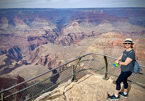
Grandview Point provides a wide view across the central and eastern Grand Canyon. Its position near the top of a projecting ridge opens the landscape in both directions rather than framing only one narrow section of the canyon.
Looking east, visitors can see several distant bends of the Colorado River. The river appears in separated sections between ridges and inner-canyon walls rather than as one uninterrupted ribbon.
The foreground includes steep slopes descending toward Horseshoe Mesa and the drainage of Hance Creek. Across the canyon, layers of cliffs and buttes rise toward the North Rim.
The overlook’s elevation also creates a strong sense of depth. Grandview Point stands approximately 7,400 feet above sea level, making it one of the higher developed viewpoints on the South Rim.
Why Grandview Point Looks Different
Grandview Point is located farther east than the developed overlooks around Grand Canyon Village. The canyon begins widening and changing orientation in this area, and the Colorado River turns through the eastern canyon below.
The result is a view that feels more open toward the east than the vistas from Mather Point or Yavapai Point. Visitors can see deeply into side canyons while also looking across long stretches of the rim.
The point’s higher elevation brings more forest into the foreground. Ponderosa pine and pinyon-juniper vegetation frame portions of the canyon and provide limited shade near the developed area.
Grandview Point History
Grandview Point was one of the canyon’s earliest developed tourist destinations. Its history is closely tied to copper mining on Horseshoe Mesa below the rim.
Around 1890, prospector Pete Berry and his partners discovered high-grade copper deposits on the mesa. They registered the Last Chance Mine claim and developed the route now known as Grandview Trail.
The trail was engineered to transport workers, supplies and copper ore between the rim and the mine. Portions of its historic cobblestone construction and cliff-supported route remain visible today.
Berry and his wife, Martha, later opened the Grandview Hotel on the rim in 1897. Visitors reached the area by stagecoach from Flagstaff before the railroad began carrying passengers to what is now Grand Canyon Village.
The arrival of the railroad in 1901 shifted tourism west toward the village. The Grandview Hotel eventually declined and was demolished in 1929. The National Park Service acquired the Grandview properties in 1941.
Little remains of the hotel at the overlook, but interpretive material and the trail itself preserve the connection between mining, early tourism and the development of Grand Canyon travel.
The Historic Grandview Trailhead
Grandview Trail begins near the canyon side of the stone retaining wall at the overlook. The trail descends steeply through the Kaibab Limestone, Toroweap Formation and Coconino Sandstone toward Horseshoe Mesa.
Its builders used stone paving, log cribs and exposed ledges to create a route through terrain that would otherwise be difficult to cross. Some historic construction survives, although landslides and trail repairs have altered other sections.
The trail’s proximity can make it look inviting from the rim. The initial descent, however, quickly enters steep and exposed terrain. A sightseeing visit should not casually become an unplanned hike.
Can You See the Colorado River?
Yes. Grandview Point provides views of several bends of the Colorado River toward the east.
The river is far below and may appear smaller than expected. Visibility depends on light, clouds, haze and wildfire smoke. Binoculars or a telephoto lens can make the river easier to identify.
Visitors primarily interested in long, unobstructed river views should also consider Lipan Point when it is open, Navajo Point and Desert View.
Is Grandview Point Worth Visiting?
Yes. Grandview Point is one of the strongest stops on Desert View Drive because it combines a major panorama, convenient vehicle access and meaningful historical context.
It is particularly worthwhile for:
- Visitors driving between Grand Canyon Village and Desert View
- Travelers who want a broad east-and-west panorama
- Photographers seeking sunrise or sunset views
- Visitors interested in early Grand Canyon mining and tourism
- Travelers who want a major viewpoint without using a shuttle
Visitors with only a few hours on the South Rim may find Mather Point more convenient. Travelers devoting half a day to Desert View Drive should place Grandview Point near the top of the route.
Grandview Point vs. Mather Point
| Grandview Point | Mather Point |
|---|---|
| Located along Desert View Drive | Located beside the Grand Canyon Visitor Center |
| Higher elevation and broader eastern views | Classic first view of the central canyon |
| Smaller parking area | Four large Visitor Center parking lots nearby |
| Connected with mining history and Grandview Trail | Connected with the Rim Trail and visitor services |
| No drinking water or full visitor center | Food, water, restrooms and information nearby |
| Best as part of a scenic drive | Best as the beginning of a first South Rim visit |
First-time visitors do not need to choose only one. Mather Point works best as an introduction, while Grandview Point adds a different eastern-canyon perspective during a longer visit.
Plan your visit to Mather Point »
Grandview Point vs. Desert View
| Grandview Point | Desert View |
|---|---|
| Broad central and eastern canyon panorama | Expansive views of the river bend and Painted Desert |
| Historic mining trail | Historic Desert View Watchtower |
| Vault toilets and picnic tables | Visitor services, food, store and seasonal campground |
| Usually a shorter stop | Can occupy one to two hours |
| About halfway along Desert View Drive | Near the park’s East Entrance |
Grandview Point is the better quick overlook. Desert View offers the more complete destination experience because of the Watchtower, services and longer river panorama.
Plan a visit to Desert View Watchtower »
Sunrise, Sunset and Grandview Trail
Sunrise at Grandview Point
Grandview Point is one of the strongest sunrise locations along Desert View Drive. The overlook’s open eastern exposure allows visitors to watch early light reach the canyon’s upper cliffs and distant formations.
Arrive 30 to 45 minutes before the published sunrise time. The sky and canyon often begin changing color well before the sun clears the horizon.
Private vehicle access makes Grandview Point easier to reach before dawn than Yaki Point or Hermit Road viewpoints that depend on shuttle schedules or seasonal road restrictions.
Use a headlamp when walking from the parking area. Stay on established paths and remain behind barriers, particularly before enough light is available to judge distance from the rim.
Sunset at Grandview Point
Grandview Point also offers strong sunset views. The broad panorama allows visitors to watch evening light move across formations to the east and west.
It is not as closely associated with sunset as Hopi Point, but it has a practical advantage: visitors can normally drive directly to the overlook rather than relying on the Hermit Road shuttle.
Parking may fill during busy evenings. Arrive well before sunset rather than expecting a space at the final moment.
Remain after the sun disappears. Twilight can soften the canyon’s colors and reduce the harsh contrast between bright cliffs and the dark inner gorge.
Compare Grandview Point with Hopi Point »
Photography Tips
- Use early or late light to bring texture into the canyon’s cliffs and side canyons.
- Look east for sections of the Colorado River and the widening eastern canyon.
- Use foreground trees and stone walls to create scale.
- Carry a longer lens for distant river bends, temples and buttes.
- Protect equipment from wind, dust, rain and snow.
- Keep tripods out of walking routes and accessible viewing areas.
- Never step beyond barriers or back toward an exposed edge while composing a photograph.
Weather and Seasonal Conditions
Grandview Point’s elevation makes it cooler than lower-elevation destinations surrounding Grand Canyon. Wind can further reduce the apparent temperature, especially near sunrise and after sunset.
Summer afternoons may bring thunderstorms. Leave exposed rim areas when lightning is nearby and do not use trees, railings or cliff edges as shelter.
Snow and ice are possible from late fall through spring. Desert View Drive may temporarily close during severe winter weather, and shaded paths can remain icy after the road reopens.
Grandview Trail is particularly hazardous in winter because its upper section is north-facing, steep and exposed. Traction devices do not transform an unfamiliar backcountry route into a beginner hike.
Should You Hike Grandview Trail?
Grandview Trail is appropriate for experienced desert hikers who understand steep canyon terrain, exposure, route conditions and the physical demands of climbing back to the rim.
The National Park Service does not recommend it as a first hike into Grand Canyon. The route is steeper, rougher and less maintained than Bright Angel Trail or South Kaibab Trail.
Important trail conditions include:
- Steep, rocky and uneven footing
- Large constructed steps
- Exposed ledges and extreme drop-offs
- No maintained drinking-water source
- Little summer shade
- Ice and snow during winter
- Limited signs and possible route-finding difficulty
Speak with a ranger or the Backcountry Information Center before attempting a substantial hike. Carry a detailed map, adequate water, food, sun protection and an emergency plan.
Day Hike to Coconino Saddle
Coconino Saddle is approximately 1.1 miles below the rim, making the hike about 2.2 miles round trip. The National Park Service estimates two to four hours and approximately 1,000 feet of elevation change.
The destination is reached only after descending steep and exposed terrain. The return climb is significantly harder than the descent.
This should not be described as an easy short hike merely because the mileage is modest. Elevation, footing, exposure and altitude increase its difficulty.
Day Hike to Horseshoe Mesa
Horseshoe Mesa is approximately three miles below the rim. NPS sources list the round trip at roughly six miles, with an estimated six to nine hours and approximately 2,500 feet of elevation change.
This is a strenuous backcountry hike for experienced canyon travelers. It should not be attempted as an impulsive add-on to a scenic drive.
The mesa contains historic mining remains associated with the Last Chance Mine. These objects are protected archaeological resources and must not be moved or entered.
Old mine openings are closed and inherently dangerous. They also provide habitat for bats and other wildlife.
Does Grandview Trail Reach the Colorado River?
No. Grandview Trail does not provide a direct route to the Colorado River.
More complex backcountry routes continue beyond Horseshoe Mesa, but they require detailed planning, navigation experience and, for overnight travel, a backcountry permit.
Visitors seeking a maintained trail toward the river should research Bright Angel Trail or South Kaibab Trail instead. A rim-to-river-and-back day hike is not recommended.
Read the complete Grandview Trail guide »
Backcountry Camping
A backcountry permit is required for all overnight camping below the rim, including camping on or near Horseshoe Mesa.
Day hiking does not require a standard backcountry camping permit, but large organized groups and certain extended itineraries may be subject to additional requirements.
Check current National Park Service regulations before finalizing an overnight route.
Parking, Accessibility and Scenic-Drive Planning
How to Reach Grandview Point
Grandview Point is located along Arizona State Route 64, also known as Desert View Drive.
From Grand Canyon Village, travel east on Desert View Drive for approximately 10.2 miles. From Desert View and the East Entrance area, travel west approximately 13.8 miles.
The viewpoint is near Mile Marker 251. Road signs identify the turnoff.
Desert View Drive is generally open to private vehicles throughout the year. Temporary closures may occur because of snow, ice, wildfire, construction or emergency activity.
Plan the complete Desert View Drive route »
Parking at Grandview Point
Grandview Point has parking for passenger vehicles as well as spaces intended for buses and RVs.
The parking area is smaller than the lots surrounding the Grand Canyon Visitor Center. It can fill during sunrise, sunset, holiday weekends and the busiest summer periods.
Use designated spaces and avoid parking along Desert View Drive or blocking the bus and oversized-vehicle area. When the lot is full, continue to another viewpoint and return later rather than creating a traffic hazard.
Accessibility
The National Park Service lists Grandview Point as wheelchair accessible. Parking and a developed viewpoint area allow visitors to see the canyon without hiking below the rim.
The historic Grandview Trail is not an accessible route. It is steep, rocky, narrow and exposed almost immediately after leaving the developed area.
Snow, ice, crowds and temporary maintenance can affect otherwise accessible surfaces. Visitors with specific mobility needs should check current park conditions before traveling.
Restrooms, Water and Food
Vault toilets are available near the parking area.
There is no drinking water or food service at Grandview Point. Carry water for every member of the group, even when planning only a short stop.
More extensive services are available at Grand Canyon Village and Desert View. Seasonal hours can change.
Picnic Tables
Picnic tables are available in the Grandview Point area. The location can be useful for a brief meal during a Desert View Drive itinerary.
Store food securely, dispose of all trash and never feed wildlife. Ravens, squirrels and other animals quickly learn to associate busy overlooks with unattended food.
Pets
Pets must remain leashed and under physical control wherever they are permitted in the park. Owners must collect and remove waste.
Pets are not permitted on trails below the South Rim, including Grandview Trail. Do not leave animals unattended in vehicles, particularly during sunny or warm conditions.
Visiting with Children
The developed viewpoint can be included in a family scenic drive, but Grand Canyon’s rim remains hazardous even where stone walls or railings are present.
- Keep young children within reach near the rim.
- Do not allow climbing or sitting on barriers.
- Keep children away from the Grandview Trail descent unless the family is properly equipped and experienced.
- Carry water, sunscreen and warm layers.
- Use extra caution when surfaces are wet, snowy or icy.
How Long Should You Spend at Grandview Point?
Allow approximately 30 to 60 minutes for the developed overlook, historical interpretation and photography.
Sunrise or sunset visits may take 90 minutes or longer when accounting for early arrival and changing light after the sun crosses the horizon.
Do not include Grandview Trail hiking in the same estimate. Even the hike to Coconino Saddle requires several hours and appropriate preparation.
Suggested Desert View Drive Itinerary
A practical eastbound itinerary from Grand Canyon Village is:
- Stop briefly at Pipe Creek Vista if parking is available.
- Visit Grandview Point for the panorama and mining history.
- Continue to Moran Point for geology and color.
- Visit Navajo Point for its high elevation and Watchtower view.
- Finish at Desert View Watchtower and the Colorado River bend.
Lipan Point is normally another priority stop, but it is closed from June 22 through December 23, 2026, for rehabilitation work.
Driving the road without stops takes much less time than experiencing it properly. Allow at least half a day when combining multiple viewpoints with Desert View.
Nearby Viewpoints and Stops
Moran Point
Moran Point lies farther east and is especially useful for seeing several major groups of Grand Canyon rock.
Navajo Point
The highest developed overlook on the South Rim provides western panoramas, a view toward the Colorado River and a striking view of Desert View Watchtower.
Desert View Watchtower
The eastern end of the scenic drive includes the historic Watchtower, visitor services and one of the South Rim’s strongest Colorado River views.
Pipe Creek Vista
Located west of Grandview Point, this developed overlook connects with the paved Rim Trail and park shuttle system.
Tusayan Pueblo
This seasonal archaeological site and self-guided trail are located closer to Desert View.
Grandview Point FAQs
Is Grandview Point worth visiting?
Yes. Grandview Point offers a broad east-and-west panorama, several distant views of the Colorado River, convenient private-vehicle access and historical interpretation related to Grand Canyon mining and early tourism.
Where is Grandview Point?
Grandview Point is located along Desert View Drive at approximately Mile Marker 251. It is about 10.2 miles east of Grand Canyon Village and 13.8 miles west of Desert View.
Can you drive to Grandview Point?
Yes. Private vehicles can normally reach Grandview Point by Desert View Drive throughout the year. Temporary road closures may occur because of snow, ice, wildfire, construction or emergency conditions.
Is there parking at Grandview Point?
Yes. Parking is available for passenger vehicles, buses and RVs. The lot can fill during sunrise, sunset and busy travel periods.
Are there restrooms at Grandview Point?
Yes. Vault toilets are available near the parking area.
Is drinking water available?
No. Drinking water is not available at Grandview Point or along Grandview Trail. Visitors should bring all the water they need.
Is Grandview Point accessible?
The National Park Service lists the developed viewpoint as wheelchair accessible. Grandview Trail is not an accessible route and quickly enters steep, rocky and exposed terrain.
Can you see the Colorado River from Grandview Point?
Yes. Several bends of the Colorado River can be seen toward the east, although the river is distant and appears in separated sections.
Is Grandview Point good for sunrise?
Yes. Its broad eastern exposure and private-vehicle access make Grandview Point one of the more practical sunrise viewpoints along Desert View Drive.
Is Grandview Point good for sunset?
Yes. Grandview Point provides broad evening views and changing light across the canyon. Hopi Point is more famous for sunset, but Grandview Point is easier to reach by private vehicle during the main season.
How high is Grandview Point?
Grandview Point is approximately 7,400 feet above sea level, making it one of the higher developed overlooks on the South Rim.
Is Grandview Trail an easy hike?
No. Grandview Trail is very steep, rugged, exposed and less maintained than the Bright Angel and South Kaibab trails. The National Park Service recommends it only for experienced desert hikers.
How far is Coconino Saddle?
Coconino Saddle is approximately 1.1 miles below the rim, or 2.2 miles round trip. The hike requires roughly 1,000 feet of elevation change and typically takes two to four hours.
How far is Horseshoe Mesa?
Horseshoe Mesa is approximately three miles below the rim. The round trip is about six miles with roughly 2,500 feet of elevation change and may take six to nine hours.
Does Grandview Trail reach the Colorado River?
No. Grandview Trail does not provide direct access to the Colorado River. Routes beyond Horseshoe Mesa require advanced backcountry planning.
Explore More Grand Canyon Viewpoints
- Best Grand Canyon Viewpoints
- Mather Point Visitor Guide
- Yavapai Point and Geology Museum
- Hopi Point Sunset Guide
- Yaki Point Visitor Guide
- Mohave Point Visitor Guide
- Navajo Point Visitor Guide